Engineering ‘green light’ for Manatua cable lay in Cook Islands waters. Important data gathered ensuring near-zero environmental impact.
Survey work has been successfully completed in Cook Islands waters for the 3500km route of the Manatua - One Polynesia fibre optic cable. As well as Rarotonga and Aitutaki in the Cook Islands, the new cable will also connect Samoa, Niue, and Tahiti and Bora Bora in French Polynesia. The cable is expected to come into service in 2020.
The work has been undertaken as part of the contract signed in November 2018 with Subcom LLC for complete turnkey delivery of the entire Manatua Cable System.
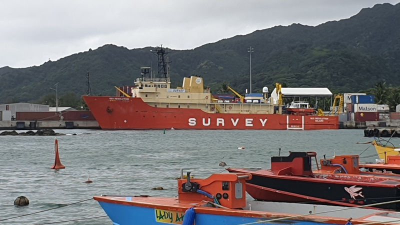
Survey vessel Geo Resolution undertook extensive sonar bathymetry survey work over the last two weeks close into the reefs on Rarotonga and Aitutaki at the selected cable landing points. The vessel is operated by survey company EGS under contract to Subcom LLC for the Manatua consortium. It is capable of high-resolution seafloor mapping using multi-beam sonar up to 5km either side of the vessel in deep water.
Within the lagoon waters inside the reef, and through the reef passages, Geo Resolution’s shallow draft 10m satellite vessel Ming Jao took over the job, towing a sonar transponder behind it.
Local divers also supported the work, using rope lines to mark the optimum cable path on the seafloor, steering the route around sensitive marine life.
Back on board the GEO Resolution, the team of engineers and scientists continuously analysed the data being returned from multiple sensors, passing it back to the Subcom in the USA and to the Avaroa Cable Ltd team in Rarotonga to scrutinise.
Continuously changing seabed conditions, including chains of sea mountains, trenches and other geological features, will require the cable to carefully weave a path through these features with pin-point precision, a challenging task in up to 5000m of water. Closer to shore, inclines of up to 70 degrees were carefully assessed in order to ensure the cable remains stable and fault-free for the next 25 years.
Rutaki passage presented the biggest challenge, with significant swell, tide and strong currents creating complex conditions for survey personnel. Nevertheless, the required data was successfully collected.
As well as being used to design the exact cable route, the data collected will also feed into the Environmental Impact Assessment which will be submitted prior to the marine cable works being undertaken. This will help confirm the impact on the environment from the cable as being near to zero. The insights gathered will also be shared in the public consultations ACL will be holding in June to update the public on plans for the cable, as well as listening and responding to any concerns people may have.
Dr Ranulf Scarbrough, ACL CEO and Vice-Chair of the Manatua Cable Consortium, said: “The Manatua cable survey team have done an excellent job in Cook Islands waters. The data being returned is some of the highest quality I have seen and provides an excellent basis on which to ensure our cable follows the safest route and the one with the lowest impact to marine life. This is a green light from an engineering perspective.”
Tatiana Burn, Chair of the Board of ACL said: “It’s great to see this important work being undertaken in such a high quality and professional fashion. Our goal for the Manatua cable has always been for world class engineering quality and this work very much lives up to that expectation.”
After a month at sea, the team on GEO Resolution enjoyed some shore leave on Rarotonga, as well as taking the opportunity to stock up on fresh supplies. The vessel will now head to French Polynesia to complete the Manatua survey work. Once all data is collected and analysed, cable manufacture can begin.